
You may read about the 5th-generation Waymo Driver but until you see one on the road, it is hard to appreciate the extent of its sensing capabilities. Sensors are visible everywhere on the all-electric Jaguar I-Pace SUV. In fact, each visible mounting location has more than one sensor. To consistently obtain the amount of information […]
RADAR/LiDAR
What is the newest use for radar in automobiles?
The use of radar in advanced driver assistance systems (ADAS) including adaptive cruise control (ACC), automatic emergency braking (AEB), pedestrian and cyclist detection and more has been widespread for many years. In these external vehicle applications, radar detects the speed and range of objects in the vicinity of the vehicle and typically operates at 77 […]
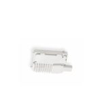
Compact LiDAR sensor integrates into autonomous mobile robots
SICK has expanded its 2D LiDAR sensor offerings for localization and anti-collision applications with the compact TiM2xx product family. This is in response to the new requirements on functionality, size, and price. Globally, the eCommerce sector continues to experience strong growth. This has also led to an increase in demand for automation solutions to support […]
How do you make iconic industrial moving equipment safer?

In the case of Bobcat construction equipment, you add radar-based sensing solutions to detect objects and people on job sites. Partnering with Ainstein AI, Inc., Doosan Bobcat North America is doing just that. Bobcat’s are frequently seen loading or unloading trucks, moving or leveling dirt, drilling, cleaning up at various locations and other activities where […]
SICK launches new PeopleCounter (PeCo) SensorApp

In reaction to new developments to slow the spread of the COVID-19 virus, SICK has launched its new PeopleCounter (PeCo) SensorApp. Using 3D LiDAR sensors, people can easily maintain recommended occupancy levels in public spaces and in manufacturing settings. Unlike the use of camera technology, the PeCo LiDAR sensor solution does not process personal information. […]
New sensor from Ibeo Automotive Systems detects environment in four dimensions
The Hamburg-based LiDAR sensor specialist Ibeo Automotive Systems GmbH will begin worldwide delivery of its new ibeoNEXT LiDAR sensor to partners and customers starting in October 2020. The sensor is based on a completely new type of photon laser measurement technology and works completely without moving parts (real solid-state). It generates an additional black-and-white image, […]
How can LiDAR be used to enforce social distancing?

The use of Lidar (Light Detection and Ranging) for automotive applications, especially autonomous vehicles, and aerial surveys is rather well known. With the COVID-19 pandemic, the technology has recently been applied to provide social distancing and help people transition to the new normal. For example, Quanergy has developed a Social Distancing Flow Management platform. It […]
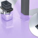
How can picture-like images be obtained from LiDAR?

At Sensors Expo 2019, Steve Ehrsam, Vice President of Sales and Marketing at Innovusion, explains how extensive details can be observed in the Innovusion Cheetah LiDAR system. Providing image-grade or picture-like images from 300 lines of angular resolution, the system can see cars over 270 meters away, detect small objects and even read signage. The […]
Image-grade LiDAR system enabled by dual rotating polygon design

Innovusion Inc. has announced the availability of its Cheetah system. Based on its innovative rotating polygon optical architecture, the system consists of proprietary detector electronics, advanced optics and sophisticated software algorithms to offer a system that has no equal in the long-distance, high-resolution LiDAR vehicle mobility system industry. Smart architecture, streamlined optics design, and integrated […]
What types of sensors are used in underwater navigation and exploration? (Part 2 of 2)

Underwater navigation and exploration require special sensors for object detection and imaging. Part 1 of this blog addressed cameras and sonar. LiDAR is also used for underwater applications. Studying the depths and shapes of underwater terrain or bathymetry can be performed by bathymetric LiDAR. The airborne approach to scanning the seafloor uses a green wavelength […]