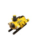
Unlike land or airborne vehicles that can use radar and cameras to locate and identify objects underwater navigation and exploration present greater challenges. If underwater visibility is good, cameras provide a good source of information. Increasing resolution and the number of cameras are among the improvements that have been made in the recent past to […]
RADAR/LiDAR
What’s new in sensors for autonomous vehicles? Part 2

Focused industry conferences were identified in Part 1 as a means of finding the latest status of the sensors used in autonomous vehicles. Another approach is a comprehensive report on the topic. With the LiDAR for Automotive & Industrial Applications report, Yole Développement provides its second insight into LiDAR technology and market aspects impacted by […]
What’s new in sensors for autonomous vehicles? Part 1

Tesla, one of the leaders in autonomous, self-driving vehicles boasts 8 vision cameras, 12 ultrasonic sensors and radar on all of the vehicles it is currently building according to recent company tweet. To make the right decisions by using the data from these sensors in the timeliest manner through sensor fusion, Tesla has developed a […]
What is the status of autonomous vehicles in industrial applications? Part 3
Many industrial applications for autonomous vehicles are in well-controlled environments that do not need the extensive mapping and understanding of varying traffic rules that impact autonomous road vehicles. Part 1 of this blog addressed the different levels of autonomous driving as defined by SAE for road vehicles and introduced the topic of autonomous farming. Part […]
What is the status of autonomous vehicles in industrial applications? Part 2
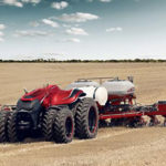
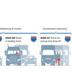
Part 1 of this blog addressed the different levels of autonomous driving as defined by SAE for road vehicles and introduced the topic of autonomous farming. This blog will provide additional information about autonomous farming applications as well as lift trucks. All of these areas are well-controlled environments that do not need the extensive mapping […]
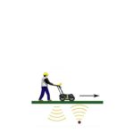
How can sensing help a railroad company manage thousands of miles of track?
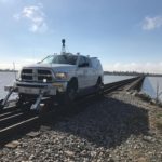
Part of the Union Pacific Railroad’s answer is in a Precision Measurement Vehicle (PMV). To develop and improve the company’s infrastructure, the PMV is used to provide accurate locations and detailed descriptions of all facilities that can be seen and measured from the track. Global Positioning System (GPS) data from the PMV provides the location […]
What advanced sensing techniques are used to find lost treasures? Part 5: LiDAR
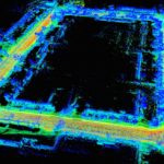
This series has previously addressed magnetometry, electromagnetic induction , ground penetrating radar and resistivity measurements. LiDAR (Light Detection and Ranging) is another sensing technique frequently used by archeologists and treasure hunters to find objects. While it can be used alone, it is often combined with electromagnetic induction, magnetometry and/or electrical resistivity measurements. LiDAR data analysis […]
What advanced sensing techniques are used to find lost treasures? Part 3: Ground penetrating radar
This series has previously addressed magnetometry and electromagnetic induction. While both of these sensing techniques are frequently used by archeologists and treasure hunters to find objects, they are often combined with ground penetrating radar (GPR) to improve the search results. Compared to other commonly available geophysical methods, GPR is the only one that provides true […]
What cool sensor-enabled products were at CES 2018? Part 6
At CES 2018, exhibit companies displayed many new products for smart homes, smart health, smart cars and more. One of the features that people expect to see in future vehicles is autonomous driving. To go beyond today’s technology demonstrations and be affordable to the masses, automotive suppliers will have to make the sensing technologies more […]
What do the latest imaging systems in airborne objects reveal? Part 2

Archeological searching is being conducted from above at altitudes well below those of satellite orbits. One group of researchers has used an airborne laser scanner (ALS) mounted to a helicopter’s skid pad to reveal several cities between 900 and 1,400 years old beneath the tropical forest floor in Cambodia. The first LiDAR (light detection and […]