• Skip to primary navigation
  • Skip to main content
  • Skip to primary sidebar
  • Skip to footer
  • Subscribe
  • Advertise

Sensor Tips

Sensor Product News, Tips, and learning resources for the Design Engineering Professional.

  • Motion Sensing
  • Vision systems
    • Smart cameras
    • Vision software
    • Lighting
    • Optics
  • Pressure
  • Speed
  • Temperature
  • Suppliers
  • Video
    • EE Videos
    • Teardown Videos
  • EE Learning Center
    • Design Guides
    • Tech Toolboxes

How can sensing help a railroad company manage thousands of miles of track?

April 26, 2018 By Randy Frank Leave a Comment

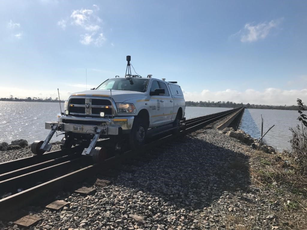
Part of the Union Pacific Railroad’s answer is in a Precision Measurement Vehicle (PMV). To develop and improve the company’s infrastructure, the PMV is used to provide accurate locations and detailed descriptions of all facilities that can be seen and measured from the track.

Global Positioning System (GPS) data from the PMV provides the location of control points and road crossings to the Positive Train Control system. Other sensors on the PMV mobile survey platform include a high-definition, 360-degree video that captures and acquires data using optical distance measurement wheels, an advanced inertial navigation system and under-vehicle mounted cameras. The data is transmitted to the railroad’s Positive Train Control (PTC) system.

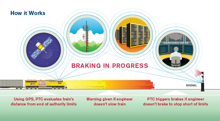
Part of the safety aspect of managing its infrastructure, PTC also uses GPS data from moving trains to automatically stop a train and prevent accidents. In particular, PTC is designed to prevent:

  • Train-to-train collisions
  • Derailments caused by excessive train speed
  • Train movements through misaligned track switches
  • Unauthorized train entry into work zones.

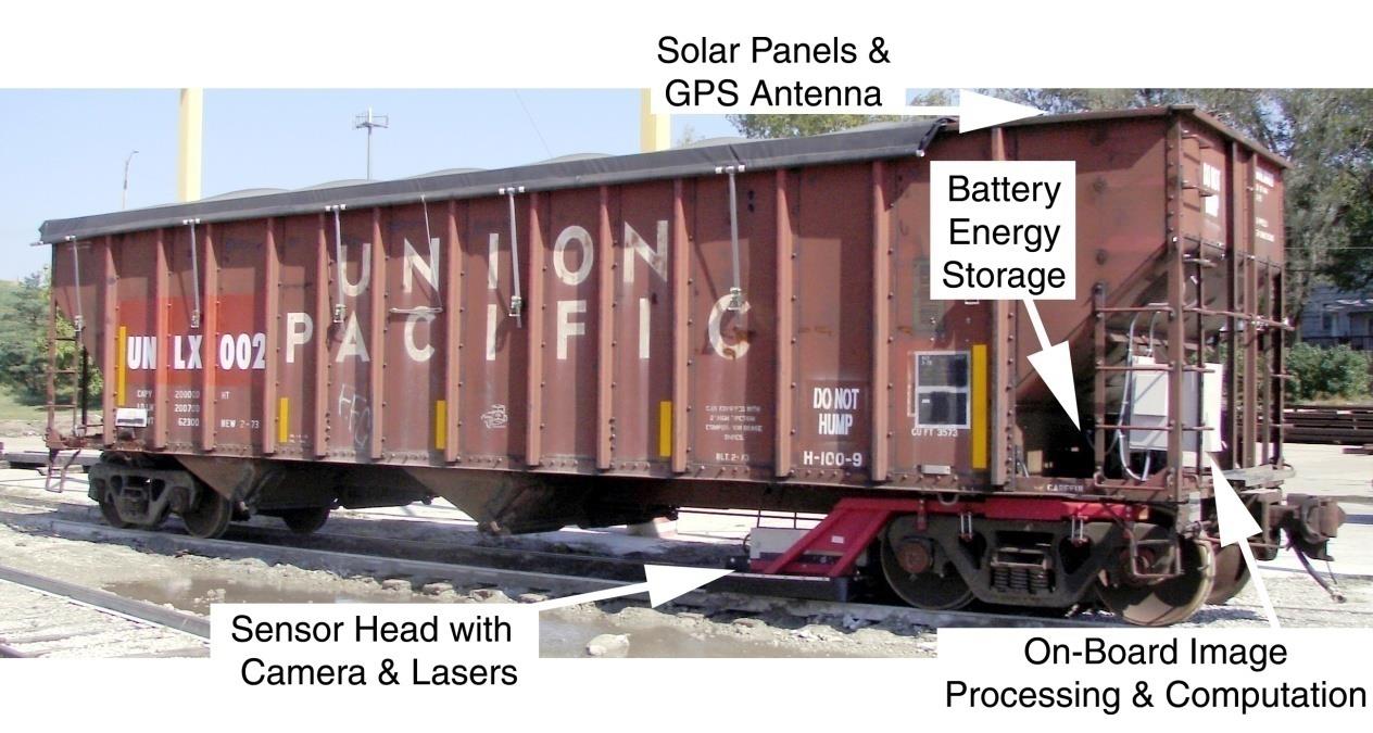
Since the tracks and foundation are a critical portion of railroad safety, measuring the deflection of the track under load is another area where sensing is employed. In his PhD dissertation, Sheng Lu describes a process to measurement real-time vertical track deflection. The test vehicle, a coal hopper, used GPS, a camera and lasers as the sensors. Solar panels and a battery energy storage provided the power for the system so the image data processing and computing could be performed on the vehicle.

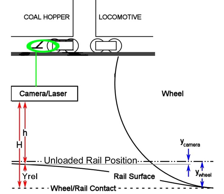
Measurements of the distance between the camera image plane and the rail surface, h. are used to calculate the displacement of the rail surface with respect to the wheel/rail contact plane, Yrel. The Yrel, value is related to ywheel, the absolute rail deflection of the wheel/rail contact point (with respect to the unloaded rail).

From these three examples, it is clear that sensing plays a critical role in railroad maintenance and safety.


Filed Under: Featured, Frequently Asked Question (FAQ), GPS (Global Positioning System), GPS Speed Sensor, RADAR/LiDAR, Time-of-Flight, Vision systems Tagged With: Union Pacific Railroad

Reader Interactions

Leave a Reply

You must be logged in to post a comment.

Primary Sidebar

Featured Contributions

Automotive sensor requirements for software-defined vehicles: latency, resolution, and zonal architecture

High-current, low-impedance systems need advanced current sensing technology

A2L refrigerants drive thermal drift concerns in HVAC systems

Integrating MEMS technology into next-gen vehicle safety features

Fire prevention through the Internet

More Featured Contributions

EE TECH TOOLBOX

“ee
Tech Toolbox: Electronic Design Automation
This Tech ToolBox helps to clear the path to faster time-to-market by digging into AI-enhanced design, hardware-assisted verification, parasitic extractions, PCB-to-harness integration, and more.

EE LEARNING CENTER

EE Learning Center
“sensor
EXPAND YOUR KNOWLEDGE AND STAY CONNECTED
Get the latest info on technologies, tools and strategies for EE professionals.

RSS Current EDABoard.com discussions

RSS Current Electro-Tech-Online.com Discussions

  • Phone to op amp circuit?
  • Very Curious Issue With DS3231 RTC Clock
  • Project boxes
  • energising a solenoid
  • Phone charger fix

EE ENGINEERING TRAINING DAYS

engineering
“bills

RSS Featured White Papers

  • 4D Imaging Radar: Sensor Supremacy For Sustained L2+ Vehicle Enablement
  • Amphenol RF solutions enable the RF & video signal chains in industrial robots
  • Implementing Position Sensors for Hazardous Areas & Safety

Footer

EE WORLD ONLINE NETWORK

  • 5G Technology World
  • EE World Online
  • Engineers Garage
  • Analog IC Tips
  • Battery Power Tips
  • Connector Tips
  • EDA Board Forums
  • Electro Tech Online Forums
  • EV Engineering
  • Microcontroller Tips
  • Power Electronic Tips
  • Test and Measurement Tips

SENSOR TIPS

  • Subscribe to our newsletter
  • Advertise with us
  • Contact us
  • About us

Copyright © 2026 · WTWH Media LLC and its licensors. All rights reserved.
The material on this site may not be reproduced, distributed, transmitted, cached or otherwise used, except with the prior written permission of WTWH Media.

Privacy Policy