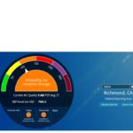
AirNow and PurpleAir report the Air Quality Index (AQI) using different methodologies. With two different techniques to measure air quality (See Pt2), how does the data from the two approaches correlate?
While AirNow’s monitors cost tens of thousands of dollars and require significant infrastructure and trained personnel to operate, PurpleAir’s sensors may only cost a few hundred dollars and can be simple to operate. However, this does not account for reading differences, that, in some instances, show raw PurpleAir data that is about two times higher than the real (AirNow) values. The uncorrected values show trends for a very specific location.
Correction factors currently available on PurpleAir come from Lane Regional Air Protection Agency (LRAPA in Oregon) or the University of Utah (AQandU) for West Coast readings. With the LRAPA conversion, the PurpleAir sensors are reasonably accurate and correlate much better to the AirNow values. However, there are two reasons for the discrepancies between the readings. The first is that the AirNow numbers are the average reading over the last hour, while the default on PurpleAir averages over the last 10 minutes. The second, and even more important, reason is that the AirNow numbers are not real time but are based on the average of the last several hours. If conditions change rapidly, the AirNow numbers will be delayed.
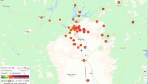
https://www.purpleair.com/map?opt=1/i/mAQI/a0/cC1#8.64/40.4827/-122.4108
In the current wildfire season, the EPA is developing a third correction factor. Until that is available, they recommend the AQandU correction method, especially if the AQI is above 150, to more closely match the AirNow values.


