• Skip to primary navigation
  • Skip to main content
  • Skip to primary sidebar
  • Skip to footer
  • Subscribe
  • Advertise

Sensor Tips

Sensor Product News, Tips, and learning resources for the Design Engineering Professional.

  • Motion Sensing
  • Vision systems
    • Smart cameras
    • Vision software
    • Lighting
    • Optics
  • Pressure
  • Speed
  • Temperature
  • Suppliers
  • Video
    • EE Videos
    • Teardown Videos
  • EE Learning Center
    • Design Guides
    • Tech Toolboxes

What types of sensors are used in underwater navigation and exploration? (Part 2 of 2)

May 24, 2019 By Randy Frank Leave a Comment

Underwater navigation and exploration require special sensors for object detection and imaging. Part 1 of this blog addressed cameras and sonar. LiDAR is also used for underwater applications.

Studying the depths and shapes of underwater terrain or bathymetry can be performed by bathymetric LiDAR. The airborne approach to scanning the seafloor uses a green wavelength of 532 nm to penetrate the water instead of the infrared wavelength of 1,064 nm used for airborne topographic LiDAR. A bathymetric LiDAR sensor consists of:

  • A Global Positioning System (GPS) receiver to provide the aircraft position,
  • An inertial measurement unit (IMU) to determine the roll, pitch and yaw of the aircraft,
  • A laser scanner to generate the signal in a particular pattern and
  • A sensor to read the returning signal.

These types of sensors are characterized as shallow-water (<10m) or deep-water systems (>10m). Improvements to new systems include:

  • The use of multiple sensors in the aircraft,
  • More system integration with additional sensors,
  • Faster transmission to data products,
  • Reflectance calibration between flight paths,
  • Greater point density,
  • Enhancements for fresh water capture and
  • Enhanced classification of point clouds.

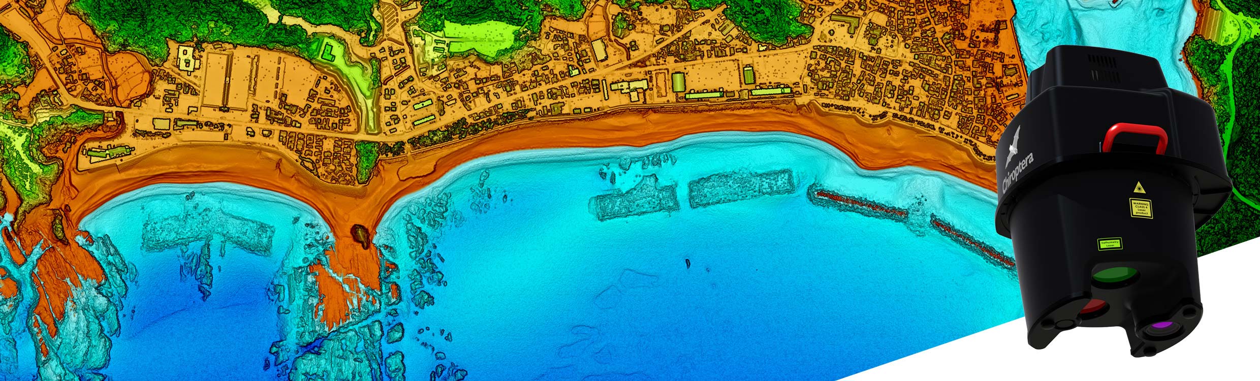
An example of an airborne bathymetric LiDAR system is the Leica Chiroptera 4X from Leica Geosystems. It simultaneously captures 140,000 points per second in the bathymetric channel (full waveform) and up to 500,000 points per second in the topographic channel. The 4X indicates a point density increase by a factor of 4 compared to previous versions. With the addition of the HawkEye 4X deep water module, water penetration down to 50m depth can be achieved.

Since available bathymetric LiDAR systems can weigh several hundred pounds, researchers at Georgia Tech Research Institute (GTRI) developed a new approach. Called Active Electro-Optical Intelligence, Surveillance, and Reconnaissance or AEO-ISR, the technology would reduce the size and weight allowing modest-sized unmanned aerial vehicles (UAVs).

Filed Under: Featured, Frequently Asked Question (FAQ), RADAR/LiDAR, Time-of-Flight Tagged With: Georgia Tech Research Institute, GTRI, Leica Geosystems

Reader Interactions

Leave a Reply

You must be logged in to post a comment.

Primary Sidebar

Featured Contributions

Automotive sensor requirements for software-defined vehicles: latency, resolution, and zonal architecture

High-current, low-impedance systems need advanced current sensing technology

A2L refrigerants drive thermal drift concerns in HVAC systems

Integrating MEMS technology into next-gen vehicle safety features

Fire prevention through the Internet

More Featured Contributions

EE TECH TOOLBOX

“ee
Tech Toolbox: Test & Measurement
We’ve gathered articles that include hands-on product tryouts and reviews. Indeed, every article in this issue uses an oscilloscope in one way or another so you might just call this “The Oscilloscope Tech Toolbox.”

EE LEARNING CENTER

EE Learning Center
“sensor
EXPAND YOUR KNOWLEDGE AND STAY CONNECTED
Get the latest info on technologies, tools and strategies for EE professionals.

RSS Current EDABoard.com discussions

RSS Current Electro-Tech-Online.com Discussions

  • EEPROM not being written or read on dsPIC30F2010
  • 12VDC ( 10 - 24 V ) to 0 to +/- 30VDC 1A dual tracking psu - for sale
  • What is involved to convert a small town to fiber optic?
  • volkswagen car stereo model rcd310
  • Dog fence help

EE ENGINEERING TRAINING DAYS

engineering
“bills

RSS Featured White Papers

  • 4D Imaging Radar: Sensor Supremacy For Sustained L2+ Vehicle Enablement
  • Amphenol RF solutions enable the RF & video signal chains in industrial robots
  • Implementing Position Sensors for Hazardous Areas & Safety

Footer

EE WORLD ONLINE NETWORK

  • 5G Technology World
  • EE World Online
  • Engineers Garage
  • Analog IC Tips
  • Battery Power Tips
  • Connector Tips
  • EDA Board Forums
  • Electro Tech Online Forums
  • EV Engineering
  • Microcontroller Tips
  • Power Electronic Tips
  • Test and Measurement Tips

SENSOR TIPS

  • Subscribe to our newsletter
  • Advertise with us
  • Contact us
  • About us

Copyright © 2025 · WTWH Media LLC and its licensors. All rights reserved.
The material on this site may not be reproduced, distributed, transmitted, cached or otherwise used, except with the prior written permission of WTWH Media.

Privacy Policy