Monitoring volcanoes is complex, and it’s an important activity to ensure public safety in many areas of the world. It involves monitoring ground deformations, earthquakes and vibrations, volcanic gas, rock and water chemistry, and remote sensing from satellites. Volcano monitoring needs to be implemented on a continuous basis or in near-real-time and is an extreme example of sensor fusion.

Monitoring gas emissions
A correlation spectrometer (COSPEC) is a ground-mounted ultraviolet spectrometer that is used to monitor sulfur dioxide (SO2) emissions. A miniaturized version called FLYSPEC can be driven or flown through the gas plume above a volcano for closer inspection of the gas emissions.
In addition, a Fourier Transform infrared spectrometer (FTIR) can be used to validate the SO2 measurements of the COSPEC or FLYSPEC and to also monitor other gases like carbon dioxide (CO2), hydrogen chloride (HCl), hydrogen fluoride (HF), Carbon monoxide (CO), and steam (water vapor). Identification of various gases, especially SO2, and their concentrations helps scientists to identify the type of magma near the surface.
Tiltmeters
Tiltmeters are important sensors for monitoring the movement of magma. When more magma accumulates underground, the surface above the magma inflates, and the slope of the surrounding areas will tilt away from the center of the uplift. And, if magma moves away from an area, it causes deflation, and the ground in adjacent areas will tilt toward the center of the subsidence. Tiltmeters are very sensitive instruments and measure the changes in tilt in microradians (about 0.00006 degrees). There are several types of tiltmeters, but most work like a standard level and consist of a small tube with a conducting fluid and a bubble to measure changes in tilt. When monitoring volcanoes, tiltmeters are often placed in boreholes 1 to 6 meters deep. Being in a borehole protects the tiltmeter and insulates it from noise and disturbances like changes in temperature and atmosphere pressure.
Strain meters
Strain meters are another tool for measuring ground movements and tracking magma. Strain meters are installed deeper than tiltmeters, often tens of meters below the surface. Common designs include liquid-filled and parallel plates. In a fluid-based strain meter, a small container of fluid changes shape and volume in response to squeezing, stretching, or shearing of the meter. Parallel plate meters measure changes in the gap between the plates caused by three-dimensional tensor strains.
Like tiltmeters, strain meters are highly sensitive and can detect the loads on Earth’s surface due to pressure changes caused by passing weather fronts and the gravitational attraction of the sun as it passes overhead. For example, strain meters installed around Yellowstone National Park identified the movement of waves on Yellowstone Lake, 20 miles away. Normally, that would not be possible, but the presence of subsurface magma amplified the strain signal of the waves. With the added data, scientists were able to precisely determine the location of the subsurface magma deposit.
Satellite remote monitoring
Satellite remote monitoring using Interferometric Synthetic Aperture Radar (InSAR) gives scientists another tool for identifying ground deformations like uplift, subsidence, or lateral shifts with millimeter accuracy. The use of satellite monitoring complements high-precision ground-based monitoring with several additional benefits:
- They can support continuous and comprehensive monitoring.
- They provide monitoring over large areas, even monitoring multiple volcanoes at once.
- Satellite monitoring eliminates the need for scientists to go into dangerous places.
Terrestrial remote monitoring
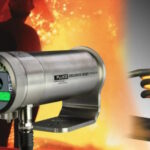
Remote monitoring doesn’t necessarily require satellites. A more cost-effective approach can be the use of thermal longwave infrared cameras to detect temperature changes on the surface of the volcano. Those cameras can detect temperatures through thick gas plumes and can provide detailed thermal information about active vents and other surface features that are not easy to access directly (Figure 2).

Volcano sensor fusion
Experiences around the 2004 eruption of Mount St. Helens in Washington State illustrate the utility of volcano sensor fusion. Initially, sensors around Mount St. Helens identified a large increase in earthquake activity. Scientists were able to correlate the increase in earthquakes with data from gas sensors, ground deformation instruments, and satellite data to identify the type of magma that was likely moving to the surface. That fusion of sensor data helped to identify the type of volcanic activity that could be expected and allowed more focused real-time data collection and analysis needed to issue warnings of potential volcanic activity.
Summary
Monitoring volcanoes is a complex process and involves measuring physical movements of the earth’s surface, gas emissions, and temperature changes. Numerous sensors are available for in situ monitoring of changing volcanic conditions and for remote monitoring. The maximum benefit is derived from fusing the data from a complex of sensors to gain better insights into potential volcanic activity.
References
Comprehensive monitoring provides timely warnings of volcano reawakening, US Geological Survey
How we monitor volcanoes, GeoNet
Role of Satellite Remote Sensing in Monitoring Volcanic Activity and Hazards, Utilities One
Thermal Cameras Used to Monitor Volcanic Activity, Thermtest Instruments